|
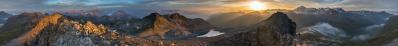
Il Lago di Santa Croce è ciò che probabilmente residua dell'antico deflusso del ghiacciaio e poi del fiume Piave attraverso la Val Lapisina (profonda un migliaio di metri dalla cima del Millifret e del Col Visentin). In epoca preistorica colossali frane e depositi morenici hanno sbarrato la strada al fiume, costringendo le acque a deviare bruscamente verso il vallone bellunese. Non sono un geologo ma secondo me le placconate rocciose alte sul fianco destro orografico della Val Lapisina testimoniano nettamente la potenza abrasiva del ghiacciaio del Piave.
Lake Santa Croce is probably what remains of the ancient outflow of the glacier and then of the Piave river through the Val Lapisina (a thousand meters deep from the top of Millifret and Col Visentin). In prehistoric times, colossal landslides and morainic deposits blocked the way to the river, forcing the waters to deviate abruptly towards the Belluno valley. I am not a geologist but in my opinion the high rocky slabs on the orographic right side of the Val Lapisina clearly witness the abrasive power of the Piave glacier.
Fuji X-E1 + XC 16-50
15 jpeg verticali a mano libera
ISO 100, 1/125 sec., f/8
Hans-Jürgen Bayer, Michael Bodenstedt, Peter Brandt, Hans-Jörg Bäuerle, Manfred Hainz, Alois Hoop, Franz Kerscher, Martin Kraus, Wilfried Malz, Gianluca Moroni, Bruno Schlenker, Jens Vischer, Benjamin Vogel, Alexander Von Mackensen
|
 |


Kommentare
Kommentar schreiben