Wassertiefstand am Lago di Luzzone   12919
previous panorama
next panorama
Details / LabelsDetails / Labels Markers on / offMarkers on / off Overview on / offOverview on / off   
 Cycle through labels:   first previous stop
play
pause
next last
  zoom out
 

Labels

1 Piz Terri 3149 m
2 Cavadröss 2632 m
3 Piz Treis Fuorclas 2988 m
4 Torno 2556 m
5 Torrone di Garzora 3017 m
6 P. 2975 m
7 Vernokhörner 3043 m
8 Plattenberg 3041 m
9 P. 3015 m
10 P. 2915 m
11 Val Scaradra
12 Pizzo Cassinello 3102 m
13 P. 2614 m
14 Torrone di Nav 2832 m
15 Stanga 2426 m
16 P. 1606 m
17 P. 2196 m
18 Forcadona 2084 m
19 P. 2044 m
20 Sosto 2221 m
21 Pizzo Molare 2585 m
22 Punta di Stou 2567 m
23 Pizzo Rossetto 2099 m
24 Pizzo di Campello 2660 m
25 Pizzo d' Era 2618 m

Details

Location: Andirö (1816 m)      by: Danko Rihter
Area: Adula/Tamina Alpen      Date: 01. Juni 2014
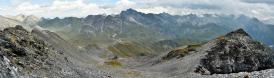
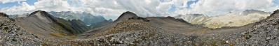
Der Pegel des Sees hat witterungsbedingt seinen Tiefstand, in den obersten Abschnitten der Täler Valle Cavalasca, Val di Larciolo, Valle di Güida, Valle di Garzora und Val Scaradra (alle im Nordtessin), hat die Schneeschmelze noch nicht gross eingesetzt. Ein Pano aus 9 HF Aufnahmen, freihand, 28 mm (KB), 1/500 sec. und Blende 9.

Comments

Sehr schönes Pano und noch wirklich reichlich Schnee auf den Bergen...

Herzlichst
Gerhard.
2014/06/21 16:07 , Gerhard Eidenberger

Leave a comment


Danko Rihter

More panoramas

... in the vicinity  
... in the top 100