Bättelmatthorn - Punta dei Camosci 360°   269305
previous panorama
next panorama
Orientation on / offOrientation on / off
Details / LabelsDetails / Labels Markers on / offMarkers on / off Overview on / offOverview on / off   
 Cycle through labels:   first previous stop
play
pause
next last
  zoom out
 

Labels

1 
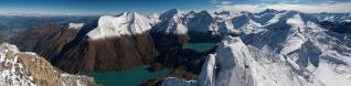
Corni di Nefelgiu 2951m
2 Monte Giove 3009m
3 Punta del Sabbia 2957m; 2,5km
4 Punta Clogstafel 2967m
5 Punta del Ghiacciaio di Ban 2975m
6 Punta Lebendun 2935m
7 Lago del Sabbione
8 2467m
9 Cima Capezzone 2421m
10 Ghiacciaio del Sabbione
11 Punta d'Arbola / Ofenhorn 3235m
12 Hohsandjoch 2901m; 5,8km
13 P. 3001m; 5,6km
14 Hohsandjoch 2901m; 6,5km
15 Rifugio 3A
16 Hohsandhorn 3182m
17 Rothorn 3287m
18 Blinnenhorn 3373m
19 Merzebachshije 3182m
20 Aletschhorn 4193m
21 Gross Wannenhorn 3905m
22 Jungfrau 4158m
23 Ritzhörner 3047m
24 Finsteraarhorn 4274m
25 Schreckhorn 4078m
26 Rosenhorn 3689m
27 Griesgletscher
28 Ritzlihorn 3282m
29 Tieralplistock 3383m
30 Fülhorn 2864m
31 Rhonegletscher
32 Dammastock 3630m
33 Galenstock 3586m
34 Fleckistock 3416m
35 Gross Muttenhorn 3099m
36 Pizzo Gallina 3061m
37 Sasshoner 3036m
38 Saashörner
39 Nufenenpass 2478m
40 Chilchhorn 2789m
41 Griessee
42 Gross Leckinhorn 3065m
43 Pizzo Rotondo 3192m
44 Passo del Corno 2485m
45 Cavistrau Grond 3252m
46 Piz Blas 3019m
47 Scopi 3189m
48 Grieshorn 2969m
49 Poncione di Valleggia 2873m
50 Marchhorn 2962m
51 Pizzo Campo Tencia 3071m
52 Poncione di Braga 2864m
53 Torrone Alto 2952m
54 Lago Castel 2210m
55 Basodino 3272m
56 1815m
57 Lago di Morasco
58 Pizzo Fiorera 2921m
59 Rifugio Citta di Busto
60 Pizzo Biela 2856m
61 Rosso di Ribia 2541m

Details

Location: Bättelmatthorn (3044 m)      by: Stefano Caldera
Area: Tessiner und Misoxer Alpen      Date: 20 Aug 2011
22 images
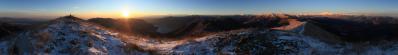
Canon EOS 7D
EF 17-40 F/4 L
17mm, 1/320s, F/11

Comments

Wonderful colours and view. Greetings Bruno.
2011/08/31 18:33 , Bruno Schlenker
an excellent view!
2011/08/31 19:04 , Danko Rihter
very lovely!
2011/08/31 19:06 , Uta Philipp
Simply great - looking forward for the full version...

Tanti saluti,
dirk
2011/08/31 19:47 , Dirk Becker
bellissimi colori... Ciao Gianluca
2011/08/31 20:18 , Gianluca Moroni
Fantastic Panorama Stefano! *BRAVO*

A few days earlier i climb Pizzo Galina at the opposite of your mountain and could enjoy the great scenery of this area! Hope to see it big next time?! Cari saluti Seb
2011/08/31 21:37 , Sebastian Becher
Very fine details and colors! BR, Volker
2011/08/31 22:20 , Volker Driesen
Bravissimo!
2011/09/01 00:16 , Beatrice Zanon
Great composition, great colours !
Kind Regards Christoph
2011/09/01 06:50 , Christoph Seger
Grazie! 
@ Seb: congratulations for the Pizzo Gallina! did you shot a panoramic? Let's see for the larger version, there is a long queue before this
2011/09/01 15:02 , Stefano Caldera
Sehr feines herrliches Panorama.
Gruss
2011/09/01 17:13 , Thomas Büchel
Soltanto... 
...fantastico!

tanti saluti d'Alfredo
2011/09/01 17:42 , Fredy Haubenschmid
Ein Panorama, das Erinnerungen an unsere Besteigung des Bättelmatthorns vor 18 Jahren weckt. Da reichte der Griesgletscher noch bis an den Griessee und hatte dort zwei mächtige Gletschertore. Der Griessee hat mit 2387m das höchste Stauziel der Schweizer Stauseen. Der auf italienischem Gebiet liegende Lago del Sabbione ist aber noch 80m höher.
Mir gefält an dem Panoramabild, das es offenbar mit Hochformataufnahmen gemacht wurde und dadurch auch die Tiefblicke in die Täler, auf die Stauseen und natürlich den Griesgletscher mit erfaßt. Dadurch wird aber die Wirkung der weiter entfernten Reihe schönster Berge etwas gemindert. Vielleicht bringt Stefano noch ein mit etwas längerer Brennweite gemachtes Panorama der Bergketten.
Ich denke aber, daß das 360°-Panorama nicht astrein gestitcht ist. Deutliches Zeichen dafür ist die schiefe Staumauer des Lago del Sabbione. Ich würde auch versuchen, in den Schatten, der auf das Fülhorn überm Griessee fällt, etwas mehr Zeichnung zu bringen.
2011/09/01 19:57 , Heinz Höra
Grazie! 
@Heinz, thanks for the information! I'm not sure to have understood all, but concerning Lago del Sabbione and the stitch, here you can find a stand-alone picture of the lake, where it is visible the prospective from the summit (helped also with a zoom on the nearest buildings): http://img84.imageshack.us/img84/9278/sabbione.jpg

ciao!
stefano
2011/09/01 20:14 , Stefano Caldera
Stefano, the stand-alone picture is also not correct. It is inclined. In the picture the barrage must be horizontal if the pictur ist made with a rectilinear objectiv. In the panorama we use cylindrical projection. Nevertheles the barrage must be (nearly) horizontal. Additionally e.g. Punta del Sabbia 2957m (only in the Panorama) and Punta del Ghiacciaio del Ban 2975m lies much too highly compared with the peaks around the Hohsandjoch, which are over 3000m.
2011/09/01 20:47 , Heinz Höra
Colori stupendi e panorama bellissima
2011/09/01 21:18 , Manfred Kostner
Grazne Manfred!
@Heinz: I've tried to make the barrage horizontal but it doesn't seem good to me:
http://img830.imageshack.us/img830/5104/batt2.jpg

I've also merged my panorama with the theoretical from Ulrich Deuschle:
http://img853.imageshack.us/img853/9218/battelm.jpg

It's not a debate, I always want to learn. Stefano
2011/09/02 11:02 , Stefano Caldera
I wanted to take off my 3D-glasses, but there were no. Very beautiful. LG Robert
2011/09/02 18:27 , Robert Viehl
Stefano, as I see in the your merge with the theoretical from UDeuschle that is'nt exactly from your originally panorama!
The debate does not resume however.
If you accept that the barrage must be nearly horizontal, then is to clarify, what wrong with the stitch.
It examines please whether you set the 0°-Höhenlinie correctly - over the entire width of the panorama. The correct 0°-Höhenlinie finds also to the comparison with UDeuschle.
2011/09/02 22:47 , Heinz Höra
Grandioso sotto ogni aspetto!
2011/09/03 11:40 , Pedrotti Alberto
Stefano, I've also merged an cutout of your panorama with the theoretical from Ulrich Deuschle:
http://www.fotocommunity.de/pc/pc/mypics/495979/display/25681391.
The theoretical is not produced from the peak of Bättelmatthorn 3044m instead of an point northeast at 3025m (Breite: 46.44115°, Länge: 8.35115°, Höhe: 3015 + 10 m) because better arrangement of Corno di Ban 3025m (not named at UDeuschle) between Monte Giove and Punta Clogstafel.
An acceptable agreement was to be only achieved, if I have turned the cutout of your panorama 0,75 degrees!!
That is the proof that your panorama is partly inclined. Then the barrage has also only the inclination, which results from the perspective distortion. I assume that the panorama is "S-förmig" bent. That results in the case of 360-Grad-panoramas, if the focal length is not correctly adjusted e.g..
2011/09/03 14:34 , Heinz Höra
Dear Heinz
so - what is the solution?? What approach do you suggest to avoid this snake-like bending of 360° panorama pictures?
Kind regards Christoph
2011/09/03 18:42 , Christoph Seger
Grazie Heinz for your calculations and congrats for your geometric eye; I'll try to improve. Anyway my goal here is only to show how beautiful the Alps are, I don't claim to have perfect panoramics in the geometrical point of view (I shot freehand, I always have many many parallax problems in the stitch), I think that a sligth inclination is acceptable if it does not disturb the observer (as happens when there are strong horizontal references, like fog, horizontal clouds, etc). Anyway your suggestions are really always very welcomed!
2011/09/06 18:40 , Stefano Caldera
Fantastico
2012/09/22 21:01 , Marco Nipoti
No S-Bend 
I don't see any s-bend in your picture. Heinz, I think you mix up Punta della Sabbia und Banhorn (Corno di Ban). What is named here Punta della Sabbia is in fact the Banhorn (Corno di Ban) and is 3025 m high. Punta della Sabbia is one summit left of it. So the relation to the Hohsandpass is perfect to my eyes.
2014/12/05 18:30 , Matthias Knapp
Matthias, 
lies bitte meinen Kommentar vom 3.9.2011. Aus diesem geht eindeutig hervor, daß ich den Berg, den Stefano als Punta del Sabbia - 2997m bezeichnet hat, schon als Corno di Ban 3025m "between Monte Giove and Punta Clogstafel" bezeichnet habe. Damit es möglichst allen einleuchtet habe ich jetzt in Weiß auch Punta Clogstafel hier eingetragen. Ich habe also nix "mix up". Wer welcher Berg ist hätte damals auch keine Rolle gespielt, weil ich mich der Art der Beweisführung, die Stefano gewählt hatte, angeschlossen hatte - und da ging es um das Übereinanderlegen der berechneten Ansicht und des Panoramabildes.
Nun zu Deinem Beweis: Bezüglich welchen Berges soll die Relation des Hohsandpasses in Deinen Augen perfekt sein? Soll es Corno di Ban (3025m) sein, der vom Bättelmatthorn 2,75km entfernt ist oder soll es Punta dell Sabbia (2957m), die 2,45km entfernt ist. Der Hohsandpass ist ja 2901m hoch und er ist nicht wie Stefano angegeben hat 6,5km entfernt sondern 5,8km. Außerdem ist er nicht dort, wo Stefano ihn im Panorama eingetragen hat, sondern weiter rechts und tiefer. Ich habe ihn jetzt - auch in Weiß - im Panorama eingetragen.
PS: Bei der intensiv geführten Diskussion um diese spezielle Einzelheit habe ich ganz vergessen, das Gesamtwerk zu würdigen.
2014/12/05 23:29 , Heinz Höra

Leave a comment


Stefano Caldera

More panoramas

... in the vicinity  
... in the top 100