
| Durchlauf: |
|
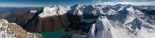
| Gran Pilastro, 3509 |
| Cima Vanscuro/Pfannspitze |
| Cima Finestra, 3171 |
| Cavallino, 2689 |
| Collaspro/Wildgall, 3286 |
| Collalto/Hochgall, 3436 |
| Lenkstein, 3236 |
| Lenkspitze, 3105 |
| Pizzo Rosso di Predoi, 3495 |
| Tre Signori, 3499 |
| Simonyspitzen, 3481 |
| Lasörling, 3098 |
| Gr. Geiger, 3360 |
| VENEDIGER, 3664 |
| Gumriaul, 2918 |
| Spitzenstein, 2265 |
| GLOCKNER, 3798 |
| Gr. Wiesbachhorn, 3564 |
| Hochschober, 3242 |
| Gr. Hornkopf, 3251 |
| Obertilliach, 1450 |
| Petzeck, 3283 |
| Hoher Sonnblick, 3106 |
| Mulleter, 2918 |
| Schareck, 3123 |
| Eggenkofel |
| Vord. Geisskopf, 2974 |
| Spitzkofel, 2717 |
| Ankogel, 3246 |
| Hochalm, 3360 |
| Sandspitzen, 2770 |
| Seekofel, 2738 |
| Wilde Sender, 2728 |
| Hohstadel, 2681 |
| Böses Weibele, 2599 |
| Riebenkofel |
| Scharnik, 2657 |
| Lumkofel, 2287 |
| Hochtristen, 2536 |
| Rosennock, 2440 |
| Falkert, 2308 |
| Latschur, 2236 |
| Zw |
| Torkarspitze, 2574 |
| Gamskofel, 2526 |
| Passo Oregone |
| Rauchkofel |
| Creta di Cjanevate/Kellerspitzen, 2774 |
| Malga Manzon, 1890 |
| Peralba, 2694 |
| Skrlatica, 2738 |
| Malga Antola |
| Prisojnik, 2547 |
| Mangart, 2677 |
| Jalovec, 2645 |
| Sorgenti del Piave |
| TRIGLAV< 2863 |
| Jôf Fuart, 2686 |
| Jôf di Montasio, 2758 |
| Modeon del Buinz, 2554 |
| Monte Cimone, 2379 |
| Cergnala, 2344 |
| Canin, 2587 |
| Lastron, 2449 |
| Amariana, 1905 |
| Cimone, 2422 |
| Rinaldo, 2473 |
| Creta Forata, 2462 |
| Siera, 2443 |
| Verzegnis, 1914 |
| Cima di Riobianco, 2400 |
| Creton di Culzei, 2458 |
| Creton di Clap Grande, 2487 |
| Monte Curie, 2035 |
| Schiaron, 2246 |
| Tinisa, 2120 |
| Terza Piccola, 2334 |
| Forcella Digon |
| Cresta di Enghe |
| Cima NE |
| Terza Grande, 2586 |
| Val Vissada |
| Bivera, 2474 |
| Clapsavon, 2462 |
| Val Frison |
| Casera Razzo |
| San Daniele, 2229 |
| Caserine, 2306 |
| Crodon di Tiarfin, 2413 |
| I Torrione |
| Campanile Peratoner |
| II Torrione |
| Forcella Mediana |
| Cornaget, 2323 |
| III Torrione |
| Brentoni, 2548 |
| IV Torrione |
| Pramaggiore, 2478 |
| Ago di Vissada |
| Cresta Castellati, 2491 |
| V Torrione |
| VI Torrione |
| Forcella Alta |
| Popera Valgrande, 2520 |
| Cima W, 2513 |
| Monfalcon di Cimoliana, 2450 |
| Torre Austria o VII Torrione |
| Monfalcon di Forni, 2453 |
| Monfalcon di Montanaia, 2548 |
| Croda dei Longerin Nord, 2571 |
| Cridola, 2581 |
| Crissin, 2503 |
| Cima W, 2564 |
| Testa Alta di Merlin, 2416 |
| Cima dei Preti, 2706 |
| Montanel, 2461 |
| Bragagnina, 2281 |
| Duranno, 2668 |
| Zita, 2191 |
| Danta di Cadore |
| Serva, 2133 |
| Pelf, 2501 |
| Schiara, 2565 |
| San Leonardo |
| Bosconero, 2468 |
| Sassolungo di Cibiana, 2413 |
| Sfornioi, 2425 |
| Talvena, 2542 |
| Rite, 2183 |
| Castello di Moschesin, 2499 |
| Gardesana, 2446 |
| Tamer Grande, 2547 |
| Ciastelin, 2570 |
| Antelao, 3263 |
| Aiarnola, 2458 |
| Pelmo, 3168 |
| Civetta, 3220 |
| Croda da Campo, 2712 |
| Tre Sorelle, 3005 |
| Croda Marcora, 3154 |
| Sorapis |
| Croda di ligonto, 2786 |
| Cima de Ambata, 2872 |
| Punta Anna, 2707 |
| Cima Bagni, 2983 |
| Ferrata Roghel |
| Popera, 3046 |
| Cima Undici, 3092 |
| Cima N |
| Passo della Sentinella |
| Cima Vinatzer |
| Croda Rossa di Sesto, 2965 |
| Tre Scarperi, 3145 |
| Cima Piatta Alta, 2905 |
| Gsellknoten, 2870 |
| Rocca Haunold, 2966 |
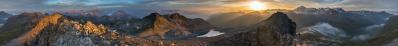
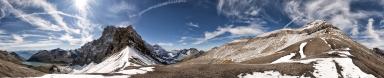
Having withdrawn "Val Visdende" due to lack of interest, I can already upload the tele version of the view from Palombino, where geography addicts can recognize more summits.
To the benefit of extreme addicts I have also sliced the view in two halves, which can be examined at static.panoramio.com/photos/original/126419061.jpg static.panoramio.com/photos/original/126419213.jpg at a size which is reasonably close to the original, and allows to single out, for example, the wonderful church of San Leonardo down in Comelico - which I have meanwhile withdrawn from Panorama Photo, due again to lack of interest. Should I detect here (who knows?) an occasional lack of lack of interest, I would proceed with the tiresome labelling.
Gefällt
21 Mal
|
||||||||||||||||
|
|||||||


Kommentare
Ciao, Alvise
I climbed on Porze (the German name) in summer 2013. It was a great tour but the view was far away from this spectacular clear view you had.
Mind if I add a few descriptions?
Thomas
Speriamo che arrivi la neve!!
Bellissima foto delle alpi carniche, saluti Patrick.
Per ora mi accontento di aver fatto in bici il bellissimo giro delle malghe di Val Visdende. Qui la bici era parcheggiata poco sopra la Dignas, dove attacca il sentiero per il Palombino.
Giuseppe: detto per inciso, questa è di casa Canon, l'altra di casa Nikon.
Martin: you are looking forward at the labels... my eyes are looking at them as well, but as for now they are seeing many things doubled. Better if I continue tomorrow!
Patrick: non vedo grosse avvisaglie di neve, per adesso...
Thomas: natürlich ist das Mitmachen willkommen... hier gibt's Arbeit für alle, besonders auf der "fremden" Seite, wo ich wenig mehr als Venediger und Glockner kenne.
Saluti, Alberto.
ciao, Alvise
Il desiderio numero uno nell'ambito dei giri vagamente alpinistici, invece, in questa foto rimane "sul retro": sarebbe la cengia alta di Cima Bagni, partendo dal Bivacco Battaglion Cadore. Era descritta come "Viaz del Popera" anche su un numero della rivista del CAI di qualche anno addietro, numero che non riesco più a trovare nella mia biblioteca.
Da ich mein Panorama Nr. 13017 damals "Zwischenstation für den Weihnachtsmann" genannt hatte, hat es auch in diesen Tagen wieder ein gewisse Aktualität.
Die Quellen sagen:
- 2597, GPS, nicht kalibriert - nur mein Bildschirm ist, in dieser Welt, weniger kalibriert als mein GPS;
- 2599, Udeuschle;
- 2599, Touring Atlas 1:200.000;
- 2600, Tabacco 1:25.000, Blatt 01, Sappada - Santo Stefano - Forni Avoltri;
- 2600, Guida dei Monti d'Italia, CAI-TCI, Alpi Carniche 2, 1995
Ich folge immer was mir die beste («most authoritative») Quelle scheint - hier die letzten zwei, die glücklicherweise dieselbe Angabe bieten.
Das gesagt, war ich auch mehr der 2599 Meter Angabe gewöhnt.
Das auch gesagt, ich bin nicht so tief von dieser 2599 vs 2600 Meter Querelle erschüttert. Nur in der letzten Woche traf ich auf Panorama Photo zwei bösere Probleme:
- San Valentín, 3910 vs 4058 M, für www.panorama-photo.net/panorama.php?pid=18840 bei 280° (weiß nicht in www.mountainpanoramas.com/___p/___p.html?panoid=2014_XZ wo der Mann seine 4070 M genommen hat...)
- Cerro Eléctrico, 2159 GPS vs 2257 Zagier&Urruty vs 2260 M Garibotti, für www.panorama-photo.net/panorama.php?pid=18839
Monte Agudo: ich erinnere, daß wir schon von diesem Berg sprachen, in einem meiner alten Marmarole-Panoramen. Nur jetzt sehe ich wie gut das Weihnachtsmann Panorama ist für was die drei Terze betrifft. Aber für den Palombino gibt von jenem Standort keine Hoffnung - mein zusätzlicher Meter wird auch das nicht heilen! Ich sehe jetzt, daß er nur in meinem höchstgelegenen Marmarole-Werk sichtbar wird: N.24070, bei 51°. (Bei 280° sehe ich dann den größsten bekannten Irfan-bug, der noch auf eine Korrektur wartet...)
Palombino: ich dachte, Italiener Bergsteiger (oder besser, Radfahrer für einen Tag als Bergsteiger verkleidet) die aus der Italienischen Seite den Berg besteigen: das erfordert den Italienischen Namen!
Das gesagt, glaube ich daß der Berg in Österreicht besser bekannt und häufiger bestiegen ist. Nicht so viel, aber, wie einige Leute glaubten, die uns sagten: Ihr könnt mit dem Fahrrad die Kasernen auf dem Grenzgrat erreichen, dann ein wenig schieben, dann findet ihr die Porzehütte offen, und die Eingangstraße geräumt (!!). Von dem Gipfel gesehen, war das alles falsch.
Außerdem, mit einem wunderschönen «Giro delle Malghe» auf der besonnten Seite noch zu vollenden (siehe www.wikiloc.com/wikiloc/view.do?id=11695455 ), hatten wir keine Interesse, auf der gefrorenen Seite abzusteigen!
LG, Alberto.
Kommentar schreiben