
| Durchlauf: |
|
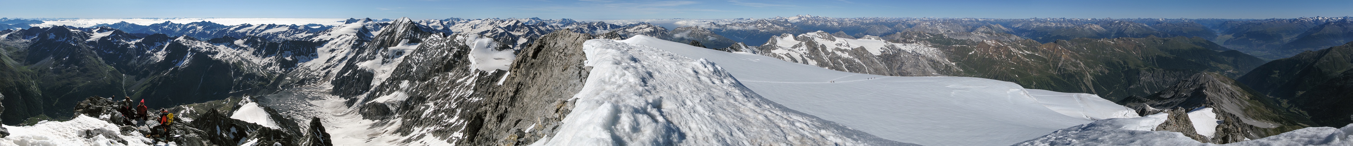
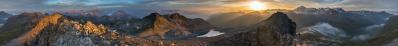
| Hochwilde, 3480 |
| Olperer, 3480 |
| Sulden |
| Zaytal |
| Hochfeiler, 3510 |
| Angelus, 3521 |
| Grossvenediger, 3674 |
| Vertana, 3545 |
| Grossglockner, 3797, 175 km |
| Hochgall, 3436, 130 km |
| Kanzel |
| Rosimferner |
| Punta dello Scudo, 3462 |
| Orecchia di Lepre, 3257 |
| Rosimtal |
| Gioveretto, 3439 |
| Marmolada, 3342 |
| Mittelstation, 2172 |
| Sternai, 3443 |
| (Val Martello) |
| Sternai Sud, 3385 |
| Pale di San Martino |
| Hintergrat Hütte, 2661 |
| Cima Rossa di Saent, 3347 |
| Hintergrat |
| Schaubach Hütte, 2581 |
| Cime Venezia, 3370 |
| Sulden Ferner |
| Cima di Solda, 3376 |
| Zufall, 3757 |
| Cevedale, 3769 |
| Minnigerode route |
| Cima Tosa, 3178 |
| Mitscherkopf |
| Ertl route |
| Langer Suldengrat |
| Gran Zebrú, 3851 |
| Taviela, 3612 |
| Suldengrat |
| Presanella, 3556 |
| Zebrú, 3735 |
| Ghiacciaio dei Forni |
| San Matteo, 3678 |
| Carè Alto, 3462 |
| Tresero, 3594 |
| Adamello, 3554 |
| Corno dei Tre Signori, 3360 |
| Corno Baitone, 3330 |
| Sobretta, 3296 |
| ALPI OROBIE |
| Pizzo di Coca, 3050 |
| Vallecetta, 3148 |
| Cime Redasco, 3139 |
| Pizzo Painale, 3248 |
| Pizzo Scalino, 3323 |
| Cima Viola, 3374 |
| Cima dei Piazzi, 3439 |
| Corni Bruciati, 3114 |
| Disgrazia, 3678 |
| Cime di Campo, 3480 |
| Bernina, 4049 |
| Madaccio di Mezzo, 3313 |
| Tödi, 3614, 129 km |
| Passo Stelvio, 2757 |
| Pass dal Fuorn, 2149 |
| Tschierv |
| Piz Linard, 3411 |
| Schesaplana, 2965 |
| Piz Buin, 3312 |
| Piz Starlex, 3075 |
| to Trafoi |
| Fluchthorn, 3399 |
| Val d'Avigna |
| Sesvenna, 3205 |
| Patteriol 3056 |
| Rif. Forcola, 2153 |
| Kuchenspitze, 3148 |
| Prader Alm, 2051 |
| Muttler, 3294 |
| Hoher Riffler, 3168 |
| Laatsch |
| Lago di Resia |
| Malles |
| Stilfs, 1302 |
| Sluderno |
| Rifugio Tabaretta |
| Glockturm, 3353 |
| Ausser Sulden |
| Val Mazia |
| Watzespitze, 3532 |
| Palla Bianca, 3738 |
| Wildspitze, 3774 |
Yesterday a new cross has been installed on the top of Ortles:
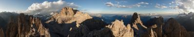
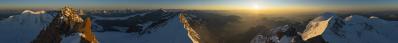
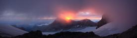
www.ski-running.com/2013/06/13/ortler/ This has given me the idea to publish this old view from my last ascent to the mountain. It encompasses nearly 340°, which means 360° minus the old cross - whence the association. The view westwards - say, from Bernina to Tödi, with the highlights of Finsteraarhorn, Eiger and Mönch (sorry, no Jungfrau) is better covered in N.19723 - please find the labels there. In a similar way, the view on the Dolomites - Sass de Putia to Pale di San Martino is far better covered in N.14130 - please find the labels there. Nine horizontal images with Canon Powershot G9, 8.2 mm x 4.6 = 37.5 mm, f/8, 1/640 sec, ISO 80. A little curiosity: According to Udeuschle, the maximum visible distance lies a bit left of the Corni Bruciati, the rocky ridge south of Monte Disgrazia. There one should see, at 298 km, the Croix Rousse and, at 304 km, a mountain which is rated 3499 m by the tool, but which should be the Ponte du Ribon, 3529 m, little north of the Rocciamelone.
Gefällt
16 Mal
|
||||||||||||||||
|
|||||||


Kommentare
lG,
Jörg E.
Wo haben die Fotos bis heute nur geschlummert??
Gruss Walter
1) auf der Festplatte;
2) auf Panoramio, wo aber einige Fehler zu finden waren
www.panoramio.com/photo/72124972
Jetzt habe ich die verbesserte Version aufgeladen (Link dazu).
Das echte Problem ist aber: Wo schlummert der Bergsteiger? Es sind jetzt schon drei Jahren, dass ich den Ortles-Cevedale, der unter meiner Lieblingsgruppen ist, nicht mehr betrete...
Ciao
Gerhard.
LG,
Andreas
Es ist ein Zweck der Photographie, und vielleicht nicht der letzte, Erinnerungen zu erwecken...
Kommentar schreiben