
| Cycle through labels: |
|
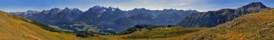
| Wannenspitz 1970m |
| Felsberger Calanda 2696m |
| Haldensteiner Calanda 2805m |
| Ringelspitz 3247m |
| Höhsäss 1824m |
| Zanaihorn 2821m |
| Pizol 2844m |
| Schwarze Hörner 2645m |
| Traza 1650m |
| Graue Hörner 2703m |
| Hochfinsler 2421m |
| Klus |
| Rheintal |
| Prodkamm 2006m |
| Prättigau |
| Federispitz 1865m |
| Vilan 2376m |
| Glegghorn 2450m |
| Falknis 2562m |
| vord. Grauspitz 2599m |
| hint. Grauspitz 2574m |
| Naafkopf 2570m |
| Tschingel 2541m |
| Hornspitz 2536m |
| Sassauna 2308m |
| Schafberg 2727m |
| Salaruelkopf 2841m |
| Schesaplana 2965m |
| Zirmenkopf 2805m |
| Seekopf 2698m |
| Girenspitz 2394m |
| Kirchlispitzen 2552m |
|
||||
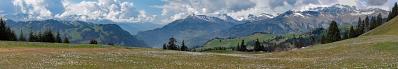
...durch die Klus bis ins Prättigau, was eher selten der Fall ist.
Freihandpano aus 12 HF-Aufnahmen mit f/6,4, 1/350s, 100 ISO, 112mm (KB) Blickwinkel ca. 135° Richtung NW (Mitte) |
||||||||||||||||
|
|||||||


Comments
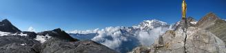
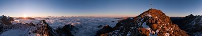
Ja, Sonntag und Montag stieg der Nebel sehr hoch, im Allgäu bis auf ca. 1500 m.
Leave a comment