
| Durchlauf: |
|
| Cret Chalam (1545m) |
| La Téte (900m) |
| Roc des Boeufs de sud (1774m) |
| Reculet (1717m - 66.1Km) |
| Cret des Neiges (1720m - 67.2Km) |
| Sommet de Precheret (1640m) |
| Dent des Portes (1932m) |
| Combi de Gex (1688m) |
| Roc de Boeufs centrale (1565m) |
| Le Grand Piton (1379m) |
| La Dole (1677m) |
| Mont Veyrier (1251m) |
| Pointe de Banc Plat (1907m) |
| Mont Baret (1253m) |
| Montagne de Lachat (1278m) |
| Mont Tendre (1679m) |
| Tete du Parmelan (1832m) |
| Lanche Close (1791m) |
| Dent de Lanfont (1824m) |
| Le Signal des Voirons (1480m) |
| Pointe de Talamarche (1850m) |
| Sous Dine (2004m) |
| Roche Parnal (1896m) |
| Les Tampes (1865m) |
| L'Arpette de Thuy (1675m) |
| Pierre Chatelard (2176m) |
| La Tournette (2351m) |
| Pointe de beccaz (2041m) |
| Pointe de Chalune (2116m) |
| Dent D'oche (2221m) |
| Pointe de Jalouvre (2438m) |
| Pointe de Banc Fleury (2009m) |
| Pointe du Midi (2364m) |
| Cret des Mouches (2033m) |
| Le Grand Bargy (2301m) |
| Mont de Grange (2432m) |
| Pointe de Chauriande (1801m) |
| Pointe de la Grande Combe (2210m - 40.2Km) |
| Pointe d'Almet (2232m) |
| Les Hauts Forts (2466m) |
| Sulens (1839m) |
| Pointe de Bella Cha (2511m) |
| Pointe Percée (2750m) |
| Mont Fleuri (2511m) |
| Tete Pelouse (2537m) |
| La Roualle (2589m) |
| La Grande Balmaz (3616m) |
| Haute cime Dents du midi (3257m - 76.7Km) |
| L'étale (2483m - 26.2Km) |
| Tour Sallière (3219m - 74.2Km) |
| Pic de Tenneverge (2989m - 69.2Km) |
| Tête du Colonney (2692m - 49.3Km) |
| Tête de l'Aulp (2131m) |
| Mont Buet (3096m) |
| Mont Charvin (2409m) |
| Les Aiguilles du Mont (2133m - 20.3km) |
| Le Christomet (1853m - 34.5Km) |
| iguille de la Tête Platte (2944m - 62.6Km) |
| Aiguille de la Floria (2888m - 60.9Km) |
| Praz Vechin (1743m - 22.3Km) |
| Aiguille du Tour (3544m - 71.5Km) |
| Aiguille du Chardonnet (3824m - 69.5km) |
| Aiguille d'Argentière (3900m - 70.4km) |
| Aiguille Verte (4122m - 65.7km) |
| Les Droites, Sommet Ouest (3984m - 66.6km) |
| L'Alpette (1615m - 13.9Km) |
| Les Courtes (3856m - 67.8km) |
| Dent du Crocodile (3640m - 59.5km) |
| Aiguille du Midi (3842m - 57.4km) |
| Dent de Cons (2062m - 12.7Km) |
| Dôme du Goûter (4304m - 52.9km) |
| Les Bosses (4547 - 53.6Km) |
| Mont Blanc (4810m - 54.2km) |
| Montriond (1714m) |
| Mont Blanc du Courmayeur (4748m - 54.4km) |
| Pointe de Cruessajaran (1961m - 11.9km) |
| Tête Blanche (3892m - 49.2km) |
| Pointe des Auges (1814m) |
| Aiguilles de Tré la Tête (3930m - 49.3km) |
| Aiguille des Glaciers (3816m - 48Km) |
| Têtes de Bellaval (2892m - 42.9km) |
| Monte Berrio Blanc (3251m - 54.9km) |
| Pointe Lechaud (3128m - 48.2km) |
| Pointe des Ouillons (3110m - 47.7Km) |
| Petite Sambuy (2107m) |
| Mont Miravidi (3066m - 48.7km) |
| Roche Plane (2166m - 25.2km) |
| Sommet des Rousses (2978m - 50.5km) |
| Pointe de la Sambuy (2198m - 5.4km) |
| Aiguille du Grand Fond 2920m - 37Km) |
| Le Roignais (2995m - 38.7Km) |
| Grande Rousse (3607m - 70.6km) |
| Pointe de Chaurionde (2173m - 4.9km) |
| Gran Paradiso (4061m - 85.6km) |
| La Legette de Grand Mort (2366m - 26.3km) |
| Le Grand Mont (2686m - 27.4km) |
| Pointe du Nant Cruet (3605m - 64.9km) |
| Aiguille Rouge (3227 - 53.1km) |
| Aiguille de la Petite Sassière (3672m - 65.8km) |
| Aiguille de la Grande Sassière (3747m - 65.9km) |
| Mont Turia (3650m - 54.7km) |
| Mont Pourri (3779m) |
| Pointe de Comborsier (2534m - 26.5Km) |
| Dome de la Sache (3601m - 56.3km) |
| Dome des Platieres (3473m - 55.9km) |
| Pointe du Montet (3428m - 74.4km) |
| L'Aliet (3109m - 53.1km) |
| Dome des Picheres (3319m - 51.9km) |
| Bellecote (3417m) |
| Pointe d'Arcalod (2217m) |
| Gran Ciamarella (3676m - 84.3Km) |
| L'Albaron (3640m - 81.2Km) |
| La Grande Motte (3683 m) |
| La Grande Casse (3856 m) |
| La Grande Lanche (2110m - 18.1Km) |
| Pointe Mathews (3786m - 58.6Km) |
| Le Grand Bec (3398m - 52.7km) |
| Pointe du Vallonnet (3539m - 67.4Km) |
| Grand Roc Noir (3582m - 67.6km) |
| Dent de Corbeau (2286m - 18.5km) |
| Pointe de Ronce (3612m - 77.4km) |
| Pointe du Dard (3206m - 57.6km) |
| La Tuile (2294m - 18.6Km) |
| Dome de Chasseforet (3586m - 59.7km) |
| Dôme des Nants (3570m - 58.9Km) |
| Le Grand Roc (1814m - 7km) |
| La Dent de Parrachée (3697m - 62.6Km) |
| Le Grand Arc (2484m - 19.2km) |
| Aiguille du Fruit (3051m - 50.Km) |
| Le Petit Arc (2365m - 19Km) |
| Pointe de l'Echelle (3422m - 60.6K) |
| Mont de la Coche (2070m - 3.7km) |
| Aiguille de Polset (3501m - 57.8Km) |
| Aiguille de Peclet (3561m - 56.6Km) |
| Pointe du Bouchet (3420m - 58.3Km) |
| Pointe de la Fougère (1849m) |
| Pic du Rognolet (2659m - 26.Km) |
| Cime de Caron (3195m - 55.6Km) |
| Le Cheval Noir (2832m - 34.6Km) |
| Aiguille de la Balme (2696m - 28.1Km) |
| Grand Pic de la lauzière (2829m - 29.2Km) |
| Tour de la Flachière (2776m - 29.4Km) |
| Rocher du Grand Jet (2678m - 29.5Km) |
| Le Gros Villan (2746m - 29.8Km) |
| Mont d'Armenaz (2080m) |
| Le Grand Coin (2730m - 41.8Km) |
| Mont Pecloz (2197m) |
| Roche Benite (2297m - 30.9Km) |
| Rocher du Vieux (2252m - 31.2Km) |
| Pointe des Cerces (3097m - 73.4Km) |
| La Setaz des Pres (2548m - 65.2Km) |
| Le Grand Galibier (3228m - 72.Km) |
| Pointe des Arces (2076m) |
| Montagne des Agneaux (3664m - 84.6Km) |
| Aiguille de l'Epaisseur (3230m - 63.5Km) |
| Le Grand Chatelard (2143m - 44.2Km) |
| Aiguille centrale d'Arves (3513m - 63.8Km) |
| Pic Lory (4088m - 86.6Km) |
| Pic Gaspard (3881m - 77.9Km) |
| Grand Pic de la Meije (3986m) |
| Le Râteau (3809m - 77.2Km) |
| Pointe des Arlicots (2060m) |
| Pic de Grave (3667m - 77.7Km) |
| Le Grand Miceau (2669m - 35.7Km) |
| Aiguille du Plat de la Selle (3596m - 81Km) |
| Le grand Parra(2012m) |
| La Cha (197m) |
| Clocher du Frêne (2789m - 37.9Km) |
| Petit Crozet ((2749m - 37.7Km) |
| Comes du grand Sauvage (3216m - 59.9Km) |
| Pic de L'Etandard (3464m - 60Km) |
| Le chapeau de Napoléon (1854m) |
| Pic de la Pyramide (3382m - 62.4Km) |
| Puy Gris (2908m - 44.3Km) |
| Col d'Arclusaz (1770m) |
| Rocher d'Aiguille (2885m - 46.5Km) |
| Le Rocher Blanc (2928m - 50.7Km) |
| Dent d'Arclusaz (2041m) |
| Pic du Col d'Ornan (2872m - 78.8Km) |
| Pic des Cabottes (2732m - 51.2Km) |
| Pic de la Belle Etoile (2718m - 51.9Km) |
| La Grande Lauzière (2741m) |
| Grand pic de Belledonne (2977m - 60.2Km) |
| Rocher de l'Homme (2755m - 58.Km) |
| L'Epion (1422m) |
| Grand Lance de Domene (2790m - 60.8Km) |
| Col du Frêne (950m) |
| Mont Charvet (1572m - 16.3Km) |
| Grand veymont (2341m - 105.4Km) |
| L'Epion (1469m) |
| Roche du Guet (1209m) |
| Rochers de Bellefont (193m - 47.9Km) |
| Roc de Tormery (1135m) |
| La Grande Moucherolle (2284m - 91Km) |
| Lances deMalissard (2045m - 45.9Km) |
| Chamechaude (2082m - 55.1Km) |
| Pic de la Sauge (162m) |
| Pointe de la Galoppaz (1681m) |
| Charmant Som (1867m - 52.9Km) |
| Grans Som (2026m - 46.7Km) |
| Rocher de Chalves (1836m - 58.6Km) |
| Rocher de Lorzier (1838m - 57.4Km) |
| Rochers de la Bade (1850m - 9.6Km) |
| Rochers de la Sure (1920m - 55.3Km) |
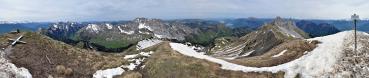
Panorama sommet du Trelod
---- Nikon D90 - Nikkor 18-70mm f/3.5-4.5 AF-S DX 43 pictures (portrait) ISO 1600, 1/2000, F10, f=70 mm (~105 mm) 02:41 PM (CEST)
Gefällt
9 Mal
|
||||||||||||||||
|
|||||||


Kommentare
LG Michael
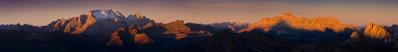
I've updated the picture with a graduated filter on the right side to reduce exposure. But I don't want to cut Chartreuse massif, even if it's quite overburned :)
Thanks also for labelling it !
BR Kathrin
Kommentar schreiben