
| Durchlauf: |
|
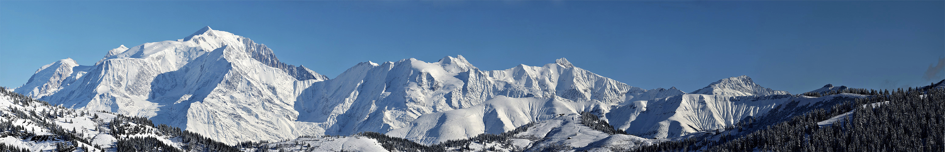
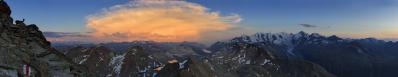
| Col du Midi 3550 m |
| Mont Blanc du Tacul 4248 m |
| Aiguille de Gouter |
| Refuge de Tête Rousse 3204 m |
| Mont Maudit |
| New Refuge du Gouter |
| Dôme de Gouter |
| Vallot Biwak |
| Arête des Bosses |
| Mont Blanc 4810 m |
| Aiguille de Bionassay 4052 m |
| Refuge Durier 3358 m |
| Point 3673 Domes de Miage |
| Domes de Miage 3670 m |
| Aiguille de Tré la Tête 3930 m |
| Mt Joly 2525 m |
| Lex Blanche ou Lée Blanche 3697 m |
| Aiguille des Glaciers 3816 m |
| Mt Tondu 3196 m |
Nikon D3OOs AFS VR 16-85 à f9 1:1000 4 vues horizontales en manuel sur monopode
Gefällt
20 Mal
|
||||||||||||||||
|
||||||


Kommentare
Salut
Dietrich
Michel
Could you please give the location coordinates, also in your other panoramas. It is easy to make if you choose "locate in the map".
You have named the Aig. des Glaciers twice, the first is the Aig. de Trélatête.
PS: I have found Chalet de la Balmaz. The coordinates are 45°53'00.3"N, 6°30'37.8"O rep. 45,88342 N, 6,50105 O.
I'm amazed that of 1600 m height, Mont Blanc as high is above the Aig. de Bionassay. This is not so of the over 1800 m high Mont d'Arbois. But this is also something closer to Mont Blanc.
Bionnassay 4052m
Mt d'Arbois invisible from here !
In the meantime I made myself a panorama of the d'Arbois.
Look at the panorama #22196 and you'll see what I meant.
Kommentar schreiben