
| Durchlauf: |
|
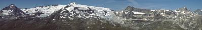
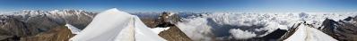
| Grand Roc Noir, 3582 m |
| Pointe du Grand Vallon, 3140 m |
| Monte Giusalet, 3300m |
| Monte Viso, 3841 m |
| Signal du Petit Mont Cenis, 3162 m |
| Rocca d'Ambin, 3378m |
| Punta Sommeiller, 3332 m |
| Montfroid |
| Rognosa d'Etache, 3373 m |
| Aiguille de Scolette, 3506 m |
| Haute Maurienne |
| Mont Pelvoux 3943 m |
| L'Ailefroide, 3954 m |
| Barre des Ecrins, 4102 m |
| Dent Parrachèe, 3697 m |
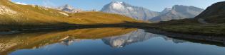
| Parking du Bellecombe |
| Pointe de Labby, 3521 m |
| Pointe du Genepi |
| Dome de l'Arpont, 3599 m |
| Dome de Chasseforet, 3586 m |
| Dome des Sonnailles, 3350 m |
| Mont Pelve, 3270 m |
| Pointe de la Rechasse, 3212 m |
| Le Grand Bec |
| Pointe de Volnets |
| Pointe Mathews, 3786 m |
| La Grande Casse, 3855 m |
| La Grande Motte, 3653 m |
| Pointe de la Sana, 3435 m |
| Gran Paradiso, 4061m |
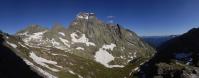
An easily accessible look-out over the Vanoise glaciers and summits in a wild and pristine corner of the Alps.
Gefällt
11 Mal
|
||||||||||||||||
|
|||||||


Kommentare
A proposito: la mia carta Didier Richard della Vanoise fa proseguire il tracciato della stradina piuttosto addentro nel vallone della Rocheure. Tale informazione è affidabile?
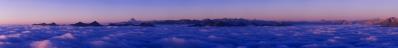
This panorama is not a full 360° because I cropped the final image to avoid including a bunch of people.
@ Alberto: la strada che sale da Termignon è asfaltata e percorribile in auto fino al parking di Belle Combe.
I sentieri all'interno dell'area protetta sono vietati alle mtb e si possono fare soltanto a piedi. In generale le carte D&R sono affidabili, ma quelle IGN in alcuni casi sono più aggiornate.
Kommentar schreiben