|
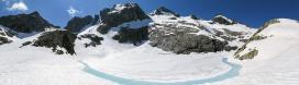
While performing a random walk on the APA map, I saw that the Punta Taviela, one of the most important among the 13 summits between Tresero and Cevedale, is represented on the site only by a work by my friend Nicola.
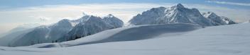
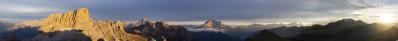
Here is a second one, which however does not "unveil" the view too much, since almost everything is shrouded in clouds...
At the end of July / beginning of August 2009 I was often back and forth on those summits: namely, I was going to leave for Bolivia, with the threat of landing at the La Paz - El Alto airport, which as 4060 metres is as high as the Gran Paradiso.
My acclimatization exercise was: go by bicycle to Peio, 1580 metres, and from there climb/traverse some of these summits (which do not present particular crevasse problems), sleeping in the tent or in some bivouac at 3400 or more metres.
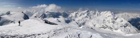
Four pictures with the Powershot G9.
Sebastian Becher, Müller Björn, Peter Brandt, Gianluca Bulgarelli, Gerhard Eidenberger, Manfred Hainz, Wilfried Malz, Werner Maurer, Uta Philipp, Jan Lindgaard Rasmussen, Patrick Runggaldier, Christoph Seger, Andreas Starick, Sieber Toni
|
 |


Kommentare
Cheers,
Andreas
Meanwhile I have discovered significant similarities with N.14130, same author, different summer.
I clearly remembered the "Finsternis weichet" version - an interesting title is a significant added value to a beautiful panorama, and acts very effectively on the mind...
Only now I see the "Wolkenschiffchen" version. To be honest, is far superior to mine, both in width and in things to see - meine Wolkenschiffchen segeln etwas höher, und decken die Dolomiten etwas mehr.
For me, the two Ortles/Taviela cloud panoramas are only little studies, and anticipations of the big cloud scenery that I was to see/record the following year: www.panorama-photo.net/panorama.php?pid=6004
Kommentar schreiben