
| Durchlauf: |
|
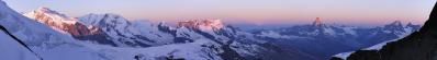
| Gamschtällihorn 2830 m |
| Erzhorn 2924 m |
| Aroser Rothorn 2980 m |
| Parpaner Rothorn 2861 m |
| Rossfallenspitz 2640 m |
| Muntaluna 2422 m |
| Haldensteiner Calanda 2805 m |
| Felsberger Calanda 2696 m |
| Piz Curver 2972 m |
| Taminser Calanda 2408 m |
| Piz Grisch 3060 m |
| Vättner Chopf 2618 m |
| Scadellagrat 2541 m |
| Drachenberg 2626 m |
| Zanaihorn 2821 m |
| P. 2712 m |
| Girenspitz 2347 m |
| Pizol 2844 m |
| P. 2684 m |
| Wildseehorn 2690 m |
| P. 2494 m |
| Wildseeluggen 2493 m |
| Sichlen 2643 m |
| Schwarze Hörner 2645 m |
| P. 2643 m |
| Schwarzseehörner 2602 m |
| Pizol Hütte 2222 m |
| Milbisand 2565 m |
| Rossstall 2456 m |
| Baseggla 2390 m |
| Gamidaurspitz 2309 m |
| Leistchamm 2101 m |
| Glattchamm 2098 m |
| Nägeliberg 2163 m |
| Schäaren 2194 m |
| Wart 2068 m |
| Selun 2205 m |
Wandergebiet; Sommer- und Wintersportdestination oberhalb Bad Ragaz im Kanton St. Gallen. Pano aus 17 HF Bilder, freihand, 58 mm (KB), 1/400 sec. und Blende 11
Gefällt
13 Mal
|
||||||||||||||||
|
|||||||


Kommentare
Kommentar schreiben