
| Durchlauf: |
|
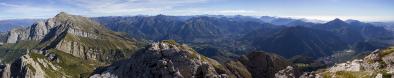
| Schalihorn (3974 m) |
| Pointe Nord de Moming (3863 m) |
| Pointe Sud de Moming (3963 m) |
| Zinalrothorn (4221 m) |
| Arête du Blanc |
| Ober Gabelhorn (4063 m) |
| Dôme de Moming (3651 m) |
| Blanc de Moming (3663 m) |
| Besso (3668 m) |
| Pointe d'Arpitetta (3132 m) |
| Pointe de Zinal (3789 m) |
| Dent Blanche (4357 m) |
| Grand Cornier (3062 m) |
| Bouquetins (3627 m) |
| Pointe de Bricola (3658 m) |
| Dent des Rosses (3613 m) |
| Pigne de la Lé (3396 m) |
| Pointes de Mourti (3564 m) |
| Dent de Perroc (3675 m) |
| Tsa de l'Ano (3367 m) |
| Pointe de Moiry (3303 m) |
| Garde de Bordon (3310 m) |
| Sasseneire (3253 m) |
Dent Blanche from Cabane de Tracuit
Gefällt
6 Mal
|
||||||||||||||||
|
||||||


Kommentare
Dein Panorama ist sehr schön, aber, leider, ziemlich schief geraten.
Dein Standort vermute ich auf 2990 m, das Horn rechts ist, warscheinlich, P. 3076 m und aus Deiner Perspektive gesehen, muss Garde de Bordon tiefer als Pointe d'Ar Pitetta erscheinen.
VG, Danko.
horozon seems to be fine to me, but if i'm wrong please provide to me more info.
Thanks
Marco
you are right, i was around 2990m, based on the map GPS should be 46°07'39''N 7°40'20''E. I double checked the name using www.udeuschle.de, https://www.peakfinder.org and other panorama on this site and name seems to be fine to me.
thanks
Marco
Schalihorn on the left is 1070 m higher than your position and only 5.4 km away from you. Do you understand, that Schalihorn has to look higher than Sasseneire? On your panorama their elevation is quite the same.
Kind regards Peter
i amended it, hope it's a little bit better now.
Thanks
Marco
Kommentar schreiben