|
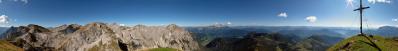
Il Col Visentin è l'ultimo e anche il più alto rilievo della lunga dorsale prealpina che separa la valle del Piave dalla pianura trevigiana (non per nulla la cima è invasa da antenne per le telecomunicazioni e da ripetitori televisivi...). Le due estremità sono date dall'attuale uscita del Piave, tra Grappa e Cesen, e la Val Lapisina che è ciò che rimane di un ramo secondario del ghiacciaio del Piave. In tempi più recenti la Val Lapisina è stata una delle porte di ingresso al centro Europa, dapprima su strade romane, poi con la veneziana Strada di Alemagna. Dalla cima del Col Visentin si vede tutta l'estensione della Regione Veneto dalla laguna quasi fino all'Austria; e in direzione est ovest dal Cornone di Blumone al Triglav.
Col Visentin is the last and also the highest relief of the long pre-alpine ridge that separates the Piave valley from the Treviso plain (therefore the summit is invaded by antennas for telecommunications and television repeaters). The two ends of the ridge are given by the current exit of the Piave, between Grappa and Cesen, and the Lapisina valley which is what remains of a secondary branch of the Piave glacier. In more recent times the Lapisina Valley was one of the gateways to central Europe, first along Roman roads, then with the Venetian Strada di Alemagna.
From the top of Col Visentin you can see the whole extension of the Veneto Region from the lagoon almost to Austria; and from Cornone di Blumone (W) to the Triglav (E).
Pedrotti Alberto, Michael Bodenstedt, Hans-Jörg Bäuerle, Günter Diez, Johannes Ha, Gerrit Hohage, Martin Kraus, Wilfried Malz, Matthias Matthey, Gianluca Moroni, Niels Müller-Warmuth, Danko Rihter, Bruno Schlenker, Adri Schmidt, Jens Vischer, Benjamin Vogel, Alexander Von Mackensen
|
 |


Kommentare
Schönes Pano und gute Dokumentation.
LG
Kommentar schreiben