
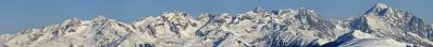
| Durchlauf: |
|
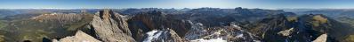
| Monte Galero 1708m, 217km |
| Monte Armetta 1739m, 222km |
| Monte Antoroto 2144m, 219Km |
| Pizzo d' Ormea 2476m, 224km |
| Bric di Conoia 2521m, 226km |
| Monte Mongioie 2630m, 226km |
| Cima della Brignola 2472m, 225km |
| Cima delle Saline 2612m, 228km |
| Punta Marguareis 2651m, 231km |
| Cima della Fascia 2495m, 233km |
| Rocca dell' Abisso 2755m, 243km |
| Monte Clapier 3045m, 250km |
| Monte Gelas 3143m, 251km |
| Punte della Rua 2779m, 244km |
| Cima di Brocan 3054m, 253km |
| Cima di Nasta 3108m, 252km |
| Cima Argentera 3297m, 251km |
| Asta Soprana 2950m, 248km |
| Punta Giegn 2888m, 256km |
| Monte Matto 3097m, 250km |
| Rocca la Paur 2972m, 251km |
| Punta Maladecia 2745m, 256km |
| Monte Tenibres 3031m, 262km |
| Punta Tempesta 2679m, 242km |
| Rocca Meia 2831m, 248km |
| Tete de Moise 3104m, 254km |
| Monte Chersogno 3026m, 243km |
| Cima delle Lobbie 3015m, 230km |
| Punta Michelis 3154m, 230km |
| Monviso 3841m, 229km |
| Visolotto 3348m, 229km |
| Punta Gastaldi 3210m, 229km |
| Punta Roma 3069m, 229km |
| Monte Aiguillet (L'Asti) 3287m, 232km |
| Crete de la Taillante 3197m, 233km |
| Le Grand Queyras 3114m, 236km |
| Pic Segure 2990m, 233km |
| Tete du Pelvas 2929m, 228km |
| Punta Cornour 2867m, 219km |
| Punta Cialancia 2855m, 217km |
| Grand Queyron 3060m, 225km |
| Punta Rognosa 3280m, 226km |
| Monte Rocciavre' 2778, 204km |
| Punta Cristalliera 2801, 205km |
| Monte Orsiera 2890m, 207km |
| Cima Ciantiplagna 2849m, 214Km |
| Monte Civrari 2302m, 186km |
| Punta Lunella 2772m, 194km |
Hard panorama with Nikon D300 and Nikon 300 f4 (F4, 1/4 sec). 14 images.
The nearest mountain is 186 kilometres away, the most distant identified, 262km.
Gefällt
7 Mal
|
||||||||||||||||
|
||||||


Kommentare
Christian
However I wonder: how is it possible to see mountains of 2500m still that high at more than 230 km? Due to the curvature of the earth an object at 250km should be about 5000 m high to be just above the horizon if you are at sea level. This is illustrated well by the remarkable picture taken from the Feldberg (at 1500 m elevation) http://www.alpen-panoramen.de/panorama.php?pid=5399&srch=feldberg which shows the Mont Blanc (4800m at 240 km dictance) only as a small bubble. So I am a bit confused when I see for instance monte Antorolo 2144m at 219 km taken from an elevation of 900 m while it should be below the horizon!
From 900 m height it is possible to view:
a) Antorolo (2144m) up till 272,4 km;
b) Galero (1708m) up till 254,6 km;
c) Armetta (1739m) up till 256,0 km.
Kommentar schreiben