
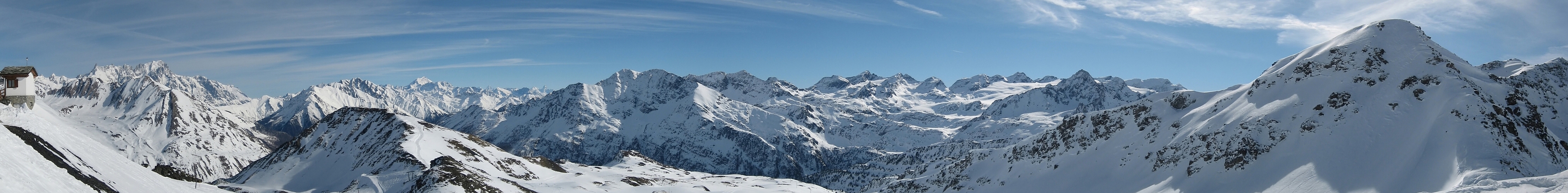
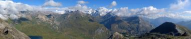
| Durchlauf: |
|
| Colle di Toula (3410m); 18km |
| Punta Helbronner (3462m); 18km |
| Colle del Gigante (3359m) |
| N |
| Dente del Gigante (4013m) |
| Aiguille de Rochefort (4001m) |
| Dom de Rochefort (4015m) |
| Colle delle Grandes Jorasses (3825m) |
| Punta Young (3996m) |
| Punta Margherita (4066m) |
| Grandes Jorasses; 19km |
| Punta Whymper (4184m) |
| Punta Walker (4208m) |
| Chaz Dura (2579m); 2km |
| Grand Rochère (3326m); 16km |
| Grand Combin (4314m); 40km |
| Mont Velan (3708m) |
| Weißhorn (4505m) |
| Dent Blanche (4357m); 66km |
| Mont Gele (3518m) |
| Mont Morion (3467m) |
| Dent d'Herens (4171m); 62km |
| Cervino/Matterhorn (4478m), 64km |
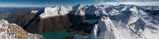
| O |
| Monte Paramont (3300m); 10km |
| Becca Bianca (3261m); 9km |
| Becca Nera (3263m); 9km |
| Pointe Chenal (3207m); 9km |
| Passo di Pianaval (3016m); 10km |
| Flambeau (3315m); 10km |
| Ghiacciaio del Rutor |
| Monte Doravidi (3439m); 10km |
| Château Blanc (3408m); 9km |
| Grande Assaly (3174m); 7km |
| Testa del Rutor (3486m); 10km |
| Becca du Lac (3402m); 9km |
| Monte Bella Valletta (2810m); 1km |
| S |
Monte Belvedere (links in pano http://www.alpen-panoramen.de/panorama.php?pid=1464) an der Italien/Frankreich grenze.
Pano aus 16 Hochformat-Aufnahmen. Blickwinkel knapp 180° richtung O EXIF Daten der erste Aufnahme Modell: Canon IXUS 55 Orig. Datum Zeit: 09.03.07 10:19 Uhr Orig. Aufnahmen in JPG F/5,6 Belichtungszeit 1/1000 s Brennweite 35mm ISO 50 Org. Grösse : 9800x2246 (22MPixel) Autostitch Neatimage ARC Soft Photo Studio
Gefällt
5 Mal
|
||||||||||||||||
|
|||||||


Kommentare
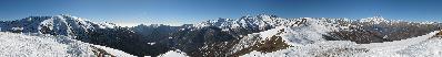
I added further description in the right side (West to South).
I'm not very familiar with Southern Aosta Valley, so I hope I described peaks correctly.
I also see it but only sometimes.
A fewer times I even see only stripes and no subject of the pano at all.
I check with some diagnostic the jpeg and if find something I will generate it again - Added 28/03/07 11:25 I regenerated jpeg, at the moment I don't see any stripes. Misteries of Information Technology...
Kommentar schreiben