|
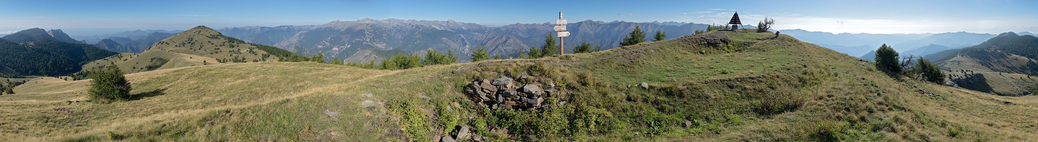
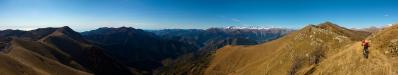
Cima di Marta is the highest summit on the border ridge south of Monte Saccarello, which is in turn the highest mountain of the region Liguria.
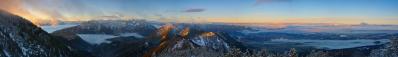
From its summit I clearly saw, for the first time, the reflection of the Mar Tirreno, in my travel from Trieste to Sanremo. This should indeed have happened well before, on the summits of Marguareis or Saccarello, but on the former I had clouds and on the latter a fierce thunderstorm.
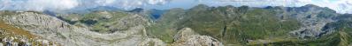
For the observation of the Val Roya the nearby Balcon de Marta would be even more suited, but it hosts a radio station which prevents the realization of a 360° view. I could realize only a partial panorama on it.
The whole Marta region is full of barracks of the second world war. Spectacular for position and extension are those (marked) on the col south of the summit, in direction Monte Grai. Some shepherds were inhabiting one of those barracks.
The long ridge between Col di Tenda and Colla Melosa, south of Monte Grai, is a dream for mountain bikes. For more than 80 km you can cycle on the border ridge, or very close to it, mostly on gravel but also with long stretches of rocky ground. The first half is also known as Strada del Sale (the salt road), and connects the Colle di Tenda to Monesi, one of the highest villages of Liguria. Now you have to pay a fee of 20 euros for cars and 15 euros for motorcycles to ride this road. A wonderful idea, which should be definitely adopted also on the Dolomitic passes. Instead of descending to Monesi (1310), one can cycle further up the the very summit of the Saccarello (2200), and from there tackle, through the nearby Passo Tanarello (2094), a tough descent carved in the French side of the mountain. This way, one reaches the Collardente ("The Burning Col", 1600), where the tradition says that in a battle of the times of Napoleon the creeks flowing down from the ridge were completely red of blood. If one is tired, from this stretch one can descend both on the French side, to La Brigue, or on the Italian side, to the wonderful Valle Argentina, with the enchanted villages of Triora, Realdo and, right at the foot of the gigantic south side of the Saccarello, Verdeggia, which, literally translated, would sound as "the greening place".
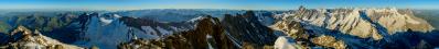
Otherwise, passing through Marta, Grai and under the nearly Dolomitic walls of Pietravecchia and Toraggio (hosting the ferrata "Sentiero degli Alpini"), one can complete a tour which is probably unique in the Alps.
If this is not yet enough, going on on asphalted roads one can climb, by fairly short side-tours, two further summits, Ceppo (1627) and Bignone (1299), before the very last descent to San Romolo and Sanremo.
Position: 44.01817 7.65646
Larger: https://bit.ly/3xUJGaP
Michael Bodenstedt, Alvise Bonaldo, Hans-Jörg Bäuerle, Günter Diez, Andre Frick, Johannes Ha, Martin Kraus, Dietrich Kunze, Uta Philipp, Bruno Schlenker, Adri Schmidt, Christoph Seger, Michael Strasser, Benjamin Vogel, Alexander Von Mackensen
|
 |


Kommentare
ciao, Alvise
Il che peraltro non è male: io sostengo sempre che le cose si gustano di piú se vengono inaspettate, anziché annunciate...
https://vimeo.com/693030121?embedded=true&source=vimeo_logo&owner=4411407
Kommentar schreiben